
Which of these things are not like the others
The districts bust out of county boundaries and start leaking and snaking all over.
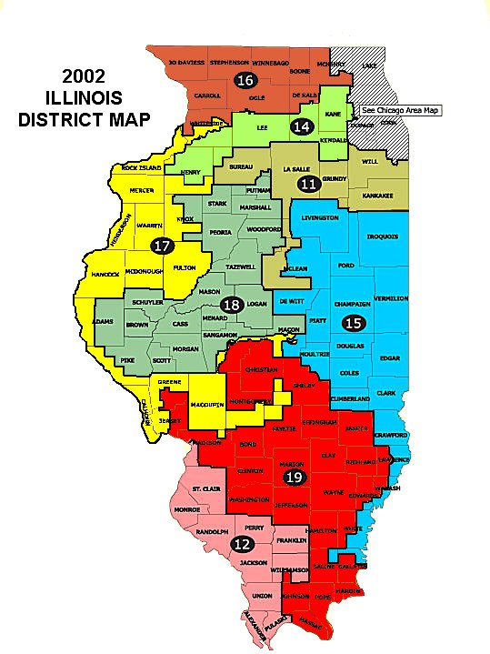
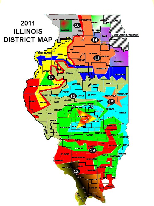
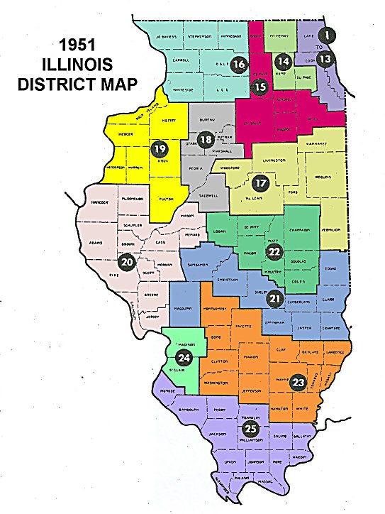
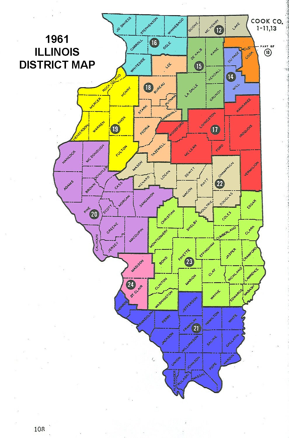
Thanks to commenter "Nicodemus" for sending along the historical maps.
posted by The Inside Dope @ 7/15/2006
4 comments
![]()


4 Comments:
It's probably that Hastert, with everyone convinced that it was Delay and not the neckless wonder who had the real power, wanted to flex his muscles the way Delay did when he perverted Texas redistricting.
At least the IL Dems didn't have to flee the legislature in the dead of night to avoid getting roped into signing their own death warrant like happened in Texas. (With Delay, of course, using the resources of the Dept. of "Homeland" security to track down their planes. And then, when reminded that that was the resources of the federal government, famously saying, "I AM the federal government.")
I was very disappointed in the Supreme Court for not ending this practice a few weeks ago. There needs to be a federal law that does not allow for these snake like districts.
As much as it helps my party in Illinois, it hurts my party in Texas. We need to be fair in this matter.
I hope the young man to whom I recently tried to explain the irrelevance of Mark Baker's 90's numbers will discover and ponder this. And Scott, this doesn't help your party in Illinois, either. Sacrificed one to build three safe ones for them, burned the dangerous dem vote where it can't hurt anybody they wanna retain.
Rob,
The goals you laid out are all sound and worthy of pursuing, perhaps aside from your desire to link Quincy and the QCs in the same district.
But I think equal weight should be given to creating districts which are somewhat compact and regular in shape.
Besides satisfying some basic ethstetic need and looking much better on a map, there are other reasons.
There is the fact that citizens should have some idea of what district they're in. Someone living in spot A shouldn't have a different representitive than people living slightly north and slightly south of them, for example. People living in one small neighborhood shouldn't have two different reps.
And conversely, bizarre mishapen districts as the 17th create hardships and confusion for the candidates as well.
Not only do they have more geographic area to cover to campaign, they also have to try to figure out what the interests are of a vastly spread out area. And when towns, citys, or regions are split up into 3 or 4 districts, how can their interests be effectively represented?
If Springfield is split into three districts, lets say, and two are Dem and one Republican, how could issues of interest to the town be effectively represented? Especially when the three districts might include other areas that are in direct competition with Springfield?
Campaigns and incumbants shouldn't have to spend hours consulting maps and legal descriptions to figure out which alley their district snakes up or down.
Nor should they have a district, such as the 17th, which is a 420 mile, over 8 hour drive non-stop from the one end to the other without leaving the district.
Or in the case of the 15th, 300 miles and a 6 hour drive from tip to tip.
To cover either district and hit most of the towns along the way would take several days.
In other words, you shouldn't be able to drive down a highway, or a city street and go in and out of a district as many as three times or more.
I'd hope that, like other states, there'd be some way to both achieve a rough balance as to population of the districts as well as make them compact and contiguous.
Post a Comment
<< Home