
Here's a detailed map of where the dividing line between the 71st and 72nd districts runs through Moline.
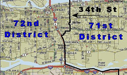
The dividing line comes in from the south east of the QC Airport, then runs west along the Rock River to I-74.
It then runs north along I-74 until it meets 27th Street and follows 27th and then zig-zags through until meeting 34th Street just south of Avenue of the Cities (aka 23rd Ave.)
It then follows 34th Street north to 18th Ave. where it takes an inexplicable left turn for a block, then turns right again on 33rd St for a block, then heads east again to meet up with 34th once more, thus taking in one particular block west of 34th for some strange reason.
It then continues to follow 34th Street to the Mississippi river.
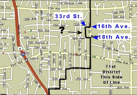
Here's a closer look at the odd diversion in the line to include a one block area. Anyone have any idea why this was done?
posted by The Inside Dope @ 11/01/2005
1 comments
![]()


1 Comments:
Just curious, does anyone have an explanation for why the line along 34th St. was altered to include the block bounded by 16th Ave, 33rd St, and 18th Ave?
Did they make that weird diversion to make sure someone who lived there was included in the 71st? Why?
Anyone have any idea?
Post a Comment
<< Home